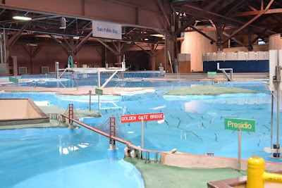
San Francisco Bay Model, Sausalito
Mary Ellen Hunt
Published 05:57 p.m., Wednesday, July 18, 2012
[From San Francisco Chronicle]
At first sight, the San Francisco Bay Model is utterly overwhelming.
Standing on the observation platform, above the acre-and-a-half scale reconstruction of the Bay Area's waterways, you can scan from the Sacramento-San Joaquin River Delta across San Pablo Bay to the Pacific Ocean. As you descend the ramps to walk closer to the edge of the waterways, you can examine the Port of Oakland and Alameda, or gaze across the Marin Headlands, the Golden Gate and beyond.
This fascinating and unique facility is one of the Bay Area's best open secrets - a remarkable tool that enables visitors to visualize and put the ecology of the bay's watershed into context. It's a terrific way to educate kids about the effects humans can have on our natural water systems. Best of all, it's free.
Built by the Army Corps of Engineers in 1957 as a way to examine the impact that John Reber's proposed dam system would have had on the bay, the model demonstrates in a concrete way the delicately interlinked natural and man-made systems that bring fresh water from the Sierra Nevada, down rivers and creeks, to meet the salt water of the Pacific Ocean.
After a two-year renovation, the Bay Model reopened earlier this year, and longtime fans will be happy to know that the familiar spots around the San Francisco Bay are all still there - including the miniature Golden Gate Bridge straddling the deep channel that leads to the ocean and the Splash Zone miniature ballpark.
Clever pumping systems enable hundreds of thousands of gallons of water to ebb and flow in tides that cycle every 14 minutes - if you watch carefully, you can actually see the water flowing through the Golden Gate, or creeping through the Suisun Slough. In 2000, when computer modeling became a more efficient way to study the impact of changes to the watershed, the Army Corps of Engineers turned the model into a one-of-a-kind educational tool.
It will take at least an hour to fully appreciate the entire facility, and scattered throughout are plenty of hands-on exhibits and video kiosks that the kids will find interesting.
What effect did dredging new shipping channels in the San Joaquin River have on the delta? How did runoff from mining during the Gold Rush change the rivers? How big is that system of dikes and levees in the delta, and what would happen if the levees failed? If you or the kids have walked along the Napa River or driven over the Carquinez Strait, if you've visited Alcatraz or landed on the runways by the bay at SFO, the Bay Model will put all your travels around our waterways into perspective.


